QZSS
The Quasi-Zenith Satellite System (QZSS) nicknamed Michibiki (=to guide, to show the way) is a regional navigation satellite system commissioned by the Japanese Government in 2002 as a National Space Development Program.
About QZSS
At the beginning the system was developed by the Advanced Space
Business Corporation team. In 2007, the work was taken over by JAXA together with Satellite Positioning Research and Application Center. The QZSS service area covers East Asia and Oceania region and its platform is multi-constellation GNSS. The QZSS system is not required to work in a stand-alone mode, but together with data from other GNSS satellites.

QZSS Space Segment
3 satellites placed in periodic Highly Elliptical Orbit (HEO) and a fourth in a geostationary orbit.
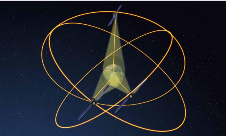
For the satellites in HEO, the perigee (perigee is the closest point and apogee is the farthest) altitude is about 32000 km and apogee altitude about 40000 km, and all of them will pass over the same ground track.

QZSS is designed so that at least one satellite out of three satellites exists near zenith over Japan. Given its orbit, each satellite appears almost
overhead most of the time (i.e., more than 12 hours a day with an elevation above 70°). This gives rise to the term "quasi-zenith" for which the system is named.

The design life of the quasi-zenith satellites is of 10 years. The first satellite Michibiki was launched on 11 September 2010 and injected into
the Quasi-Zenith Orbit on 27 September.
QZSS Frequencies

QZSS Ground Track and Control Stations
Ground stations constantly monitor the GPS signals for the generation of correction messages that are then sent to the QZSS satellites for
immediate-rebroadcast to all augmentation-enabled receivers in the coverage area with an overall turnaround of under five seconds. Augmentation messages include information such as differential correction, satellite orbit error,
ionospheric delay and other parameters.

QZSS Benefits