IRNSS/NAVIC(नाविक)
The Indian Regional Navigation Satellite System (IRNSS) with an operational name of NAVIC (नाविक)("sailor" or "navigator" in Sanskrit, Hindi and many other Indian languages, which also stands for NAVigation with Indian Constellation) is an autonomous regional satellite navigation system.
About IRNSS
IRNSS will be an independent and autonomous regional navigation system aiming a service area of about 1500 km around India. IRNSS is being developed by Indian Space Research Organization(ISRO) which would be under the total control of Indian Goverment.
Need for IRNSS?
The requirement of such a navigation system is driven by the fact that access to Global Navigation Satellite Systems, GPS is not guranteed in hostile situations.
During the Kargil war in 1999, when Pakistani troops took the position in high mountains, one of the first things Indian Military was trying to get their hands on was GPS data of the region. GPS could've provided vital information, but the United States denied access to India. The experience at Kargil made the nation realize the importance of indigenous navigation system and hence the idea of IRNSS began to take shape. With the help of IRNSS, India will become self-reliant to keep a close watch on its boundaries and much more.
IRNSS Architecture
The IRNSS constellation consist of 7 satellites, 3 are in the geostationary orbit and 4 are in the geosynchronous orbits with the required inclination and equatorial crossings in two different planes. All the satellites (IRNSS 1A -1G) of the constellation are configured identically.
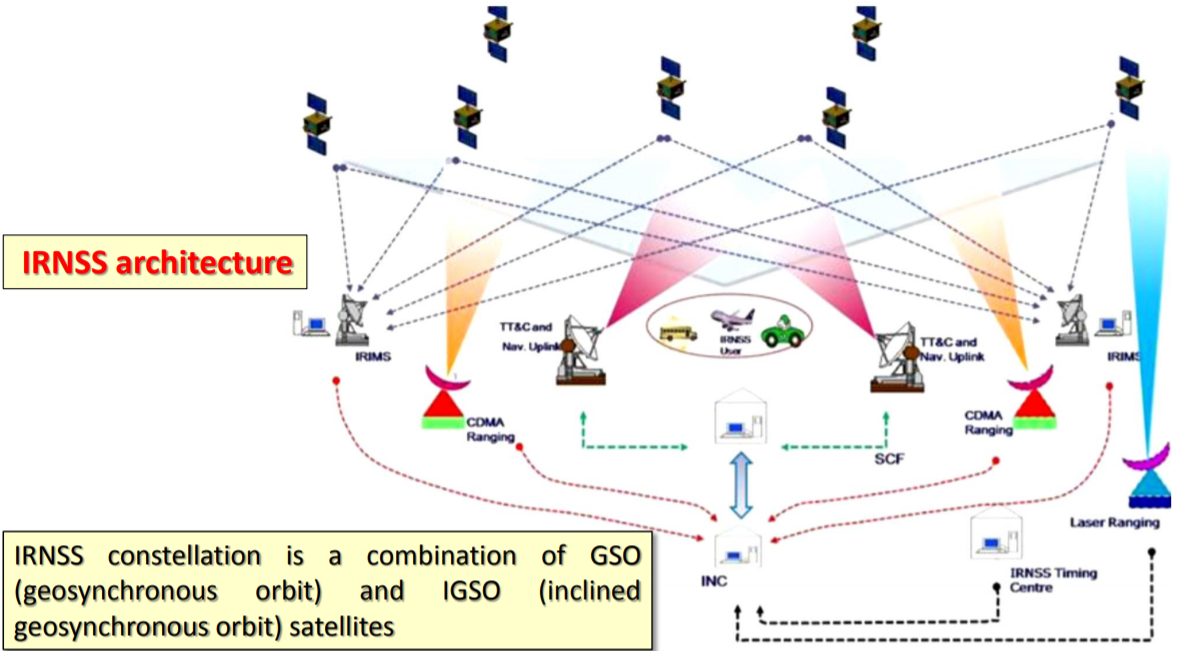

NavIC will provide accurate real time positioning and timing services. It will cover India and a region extending 1500 km around it, with plans for further extension. The system at-present consist of constellation of 7 satellites, with two additional satellites on ground as stand-by.

IRNSS will provide two types of services:
- Standard Positioning Service(SPC), which is provided to all the users.
- Restricted Service(RS), which is an encrypted service provided only to the authorized users.
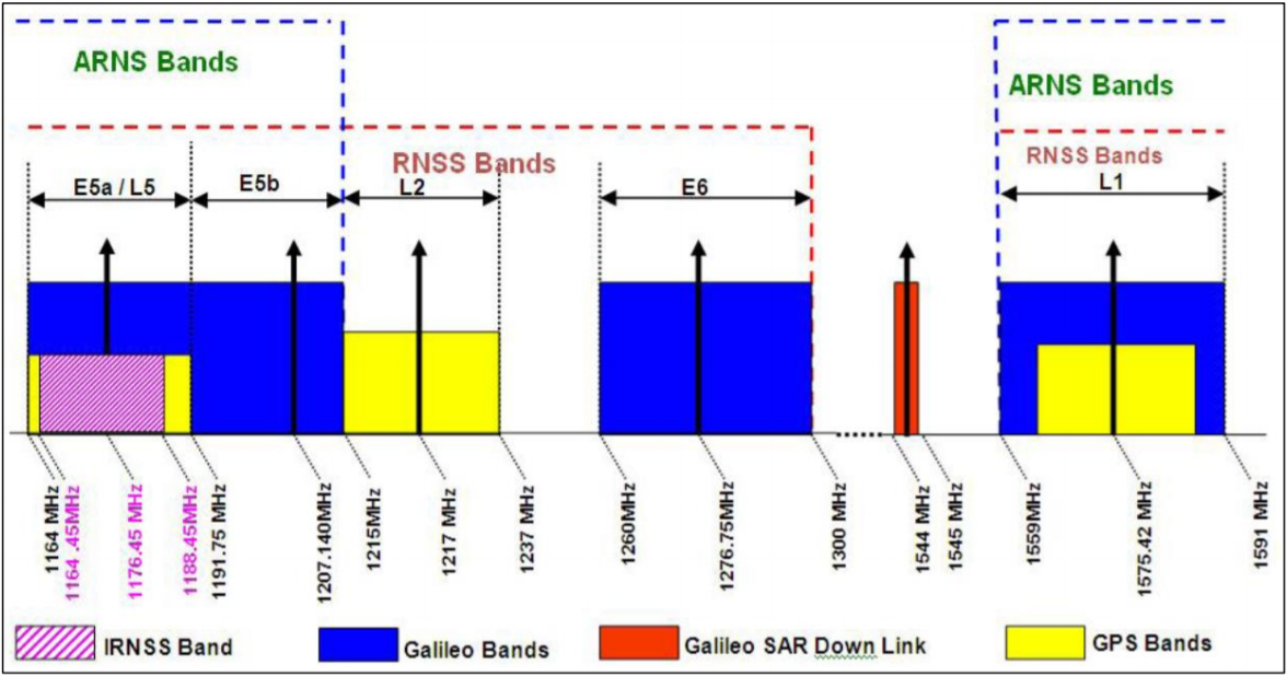
IRNSS Frequency Bands
The IRNSS SPS is transmitted on L5(1164.45 - 1188.45 MHz) and S92483.5 to 2500 MHz) bands. The frequency in L5 band has been selected in the allocated spectrum of Radio Navigation Satellite Services as indicated in the below figure for L band and S band.
IRNSS System Time
- The IRNSS System Time started at 00:00 UT on Sunday August 22nd 1999(midnight between August 21st and 22nd).
- At the start, IRNSS system time is ahead of UTC by 13 leap seconds. i.e. IRNSS time, August 22nd 1999, 00:00:00 corresponds to UTC time August 21st 1999, 23:59:47.
IRNSS Navigation Data
- Primary Navigation Parameters
- Satellite Ephemeris
- Satellite clock correction parameters
- Satellite & signal health status
- User Range Accuracy
- Total group delay
- Secondary Navigation Parameters
- Satellite Almanac
- Ionospheric grid delays and confidence
- IRNSS Time offsets with respect to UTC & GNSS
- Ionospheric delay correction coefficients
- Text Messages
- Differential Correction
- Earth orientation parameters

IRNSS User Segment
IRNSS receivers will be dual-frequency receivers(L5 and S band frequencies) or single frequency(L5 or S band frequency) with capability to receive ionospheric correction. The receivers will be able to receive and process navigation data from other GNSS constellations and the IRNSS satellites will be continuously tracked by the user receiver.
Application of IRNSS
- Terrestrial, Aerial and Marine Navigation
- Disaster Management
- Vehicle tracking and fleet management
- Integration with mobile phones
- Precise Timing
- Mapping and Geodetic data capture
- Terrestrial navigation aid for hikers and travelers
- Visual and voice navigation for drivers.
GPS vs नाविक
- GPS has 31 satellites, while IRNSS has only 7 satellites. So, how will we get an accurate location from IRNSS?
- Earlier ISRO Chairman A.S Kiran Kumar mentioned that “24 functional satellites of GPS is for the entire globe, while 7 satellites of IRNSS is covering only India and its neighbouring countries. All these 7 satellites will be visible to the ground receiver all the time.”
- Further, in the case of IRNSS, the seven satellites are in geosynchronous orbits hence always visible to a receiver in a region 1500Km around India.
- Another point is that the satellites are nearly vertical over India and therefore visibility in ‘urban canyons’ is much better than in the case of the GPS.
- Tapan Misra, then Director of Satellite Application Center [SAC], believes that NavIC is going to be better than GPS.
