BeiDou(北斗)
BeiDou is the Global Navigation Satellite System (GNSS) system developed by China to provide all-time, all-weather and high-accuracy positioning, navigation and timing services to global users.
About BeiDou
BeiDOu is China's navigation satellite system. Originally is was a regional navigation satellite system consisteing of 14 satellites. Later on it was expanded to provide global coverage. The global system will consist of 5 geostationary earth orbit satellites, 3 inclined geosynchronous orbit satellites and 27 medium earth orbit satellites. BeiDou consists of two separate satellite constellations.
-
BeiDou-1
It consist of three satellites which since 2000 has offered limited coverage and navigation services, mainly for users in China and neighbouring regions. This system was decommissioned at the end of 2012. -
BeiDou-2
This is the second generation of the system, also known as COMPASS or BeiDou-2, became operational in China in December 2011 with a partial constellation of 10 satellites in orbit. It became operational from 2012.
Orbital Characteristics

BeiDou Orbital Constellation

BeiDou: Types of satellites
| Characteristics | GEO and IGSO Satellites | MEO Satellites |
|---|---|---|
| Prime | Chinese Academy of Space Technology | Chinese Academy of Space Technology |
| Satellite Platform | DFH -3/3B | DFH - 3B |
| Lifetime | ~15 Years | ~12 Years |
| Weight | 828 kg | 1615 kg |
| Signals | B1 (Open and authorized access) B2 (open access) B3 (authorized access) |
В1 (open and authorized access) В2 (open access) В3 (authorized access) |
| Onboard Atomic Frequency Standard | 2Rb | 2Rb |
| Additional Capabilities | Laser Relflectors Cosmic ray registration |
Laser reflectors Cosmic ray registration |
BeiDou: Navigation Radio Signals
- BeiDou transmits navigation signals in three frequency bands: B1, B2, and B3, which are in the same area of L-Band as other GNSS Signals
- To benefit from the signal interoperability of BeiDou with Galileo and GPS, China announced the migration of its civil B1 signal from 1561.098 MHz to a frequency centered at 1575.42 MHz — the same as the GPS L1 and Galileo E1 civil signals.
- Its transformation from a quadrature phase shift keying (QPSK) modulation to a multiplexed binary offset carrier (MBOC) modulation similar to the future GPS L1C and Galileo’s E1


BeiDou: Spectral Characteristics of Navigation Signals
| Range | Carrier frequency(MHz) | Signal | PRN code duration, symbols | Clock Rate | Type of modulation | Data symbol rate, bit/s |
|---|---|---|---|---|---|---|
| B1 | 1575, 42 | B1-CD B1-CP B1D B1P |
2046 | 1,023 1,023 2,046 |
MBOC (6, 1, 1/11) MBOC (6, 1, 1/11) BOC (14, 2) |
50/100 no 50/100 |
| B2 | 1191,79 | B2aD B2aP B2bD B2bP |
2046 | 10,23 10,23 10,23 10,23 |
AltBOC (15, 10) AltBOC (15, 10) AltBOC (15, 10) AltBOC (15, 10) |
25/50 no 50/100 no |
| B3 | 1268,52 | B3 B3-AD B3-AP |
10,23 2,5575 2,5575 |
QPSK (10) BOC (15, 2,5) BOC (15, 2,5) |
Chinese Academy of Space Technology |
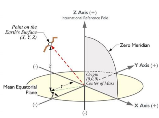
BeiDou: Geodetic Reference System and Time Scale
- BeiDou satellites motion parameters are transmitted in CGCS2000 (China Geodetic Coordinate System 2000).
- Its origin is the center of mass of the whole Earth.
- Its Z-axis directs from the origin to the reference pole of the International Earth Rotation Service (IERS Reference Pole).
- Its X-axis directs from the origin to the intersection between IERS Reference meridian and the plane perpendicular to Z-axis.
- Its Y-axis completes a right-handed, EarthCentered Earth-Fixed (ECEF) orthogonal coordinate system.
BeiDou's Countrol Segment
- Master Control Station (MCS) - 1
- Upload Stations (US) - 2
- Widely distributed Monitoring Stations (MS) - 30
- Similar to the control of other GNSS constellations, the MCS receives data from the Monitoring Stations which track the constellation continuously.
- The Upload Stations send the data generated information by the MCS to the satellites.
BeiDou's Accuracy
- There are two levels of service provided - a free service to civilians and licensed service to the Chinese goverment and Military
- The free civilian service has positioning accuracy:10m
- Timing Accuracy:20ns
- Velocity Accuracy:0.2m/s
- The restricted military service has a location accuracy of 10 centimetres can be used for communication, and will supply information about the system status to the user
- To date, the military service has been granted only to the People's Liberation Army and to the Military of Pakistan.