GALILEO
Galileo is Europe’s own global navigation satellite system, providing a highly accurate, guaranteed global positioning service under civilian control.
About GALILEO
Galileo is inter-operable with GPS and GLONASS. This system started its initial services to public authorities on December 15th, 2016. Galileo receivers compute their position in the Galileo Reference System using satellite technology and based on triangulation principles.The constellation system completion scheduled for 2020. Galileo navigation signals provide coverage at all latitudes. The Galileo navigation signals will provide good coverage even at latitudes up to 75 degrees north, which corresponds to Norway's North Cape - the most northerly tip of Europe - and beyond. The large number of satellites together with the carefully - optimised constellation design, plus the availability of the three active spare satellites per orbital plane, will ensure that the loss of one satellite should have no discernible effect on the user.
Galileo Reference System
The Galileo Terrestrial Reference Frame (GTRF) is used for the Galileo navigation system; currently defined as International Terrestrial Reference Frame (ITRF) - 2005.
An International Terrestrial Reference Frame (ITRF) is a realization of the
International Terrestrial Reference System (ITRS). The ITRS describes procedures for creating reference frames suitable for use with measurements on or near the Earth's surface.
The ITRS and ITRF solutions are maintained by the International Earth Rotation and Reference Systems Service (IERS). GTRF is defined by the European Space Agency (ESA). Practical navigation systems are in general referenced to a specific ITRF solution, or to their own coordinate systems which are then referenced to an ITRF solution. The difference between the latest WGS84 and the latest ITRF is only a few centimetres.
How Galileo Started?
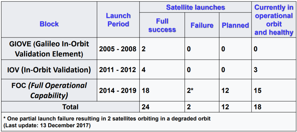
Experimental satellites GIOVE-A and GIOVE-B were launched in 2005 and 2008
respectively, serving to test critical Galileo technologies, while also the securing of the Galileo frequencies within the International Telecommunications Union. Over the course of the test period, scientific instruments also measured various aspects of the space environment around the orbital plane, in particular the level of radiation, which is greater than in low Earth or geostationary orbits. Operational Galileo satellites launches began in 2011, extending across the rest of the decade so far.
Galileo Space Segement
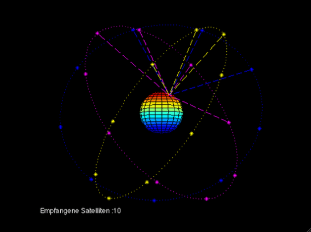
The fully deployed Galileo system will consist of 24 operational satellites plus six in-orbit spares, positioned in three circular Medium Earth Orbit (MEO) planes at 23,222 km altitude above the Earth, and at an inclination of the orbital planes of 56 degrees to the equator.
| Satellites | 24 operational satellites plus six in-orbit spares |
| Orbital Planes | 3 |
| Orbit Inclination | 56° |
| Orbit Radius | 23 222km |
Summary of Satellites
Search and Rescue Function
Further, Galileo is providing a global Search and Rescue (SAR) function, based on the operational Cospas-Sarsat system. Satellites are therefore equipped with a transponder, which is able to transfer the distress signals from the user transmitters to regional rescue co-ordination centres, which will then initiate the rescue operation. At the same time, the system will send a response signal to the user, informing him that his situation has been detected and that help is on the way. This feature is new and is considered a major upgrade compared to the existing system, which does not provide user feedback.
Ground Infrastructure
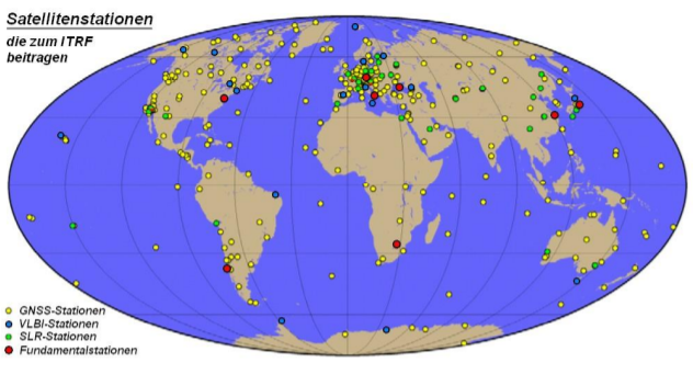
Two Galileo Control Centres (GCCs) have been implemented on European ground to provide for the control of the satellites and to perform the navigation mission management. The data provided by a global network of twenty Galileo Sensor Stations (GSSs) are sent to the Galileo Control
Centres through a redundant communications network.
Ground Segment
The GCCs use the data from the Sensor Stations to compute the integrity
information and to synchronise the time signal of all satellites with the
ground station clocks. The exchange of the data between the Control Centres and the satellites is performed through up-link stations.
Galileo Control Segment’s functions are:
- To control and maintain the status and configuration of the satellite constellation.
- To predict ephemeris and satellite clock evolution.
- To keep the corresponding GNSS time scale (through atomic clocks).
- To update the navigation messages for all the satellites.
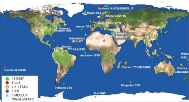
The system's orbit and signal accuracy is controlled by a ground segment consisting of:
- 2 Ground Control Centres, located in Oberpfaffenhofen and Fucino for Satellite and Mission Control
- 5 telemetry, tracking & control (TT&C) stations, located in Kiruna, Kourou, Nouméa, Sainte-Marie, Réunion & Redu
- Several worldwide distributed mission data uplink stations (ULS)
- Several worldwide distributed reference sensor stations (GSS)
- A data dissemination network between all geographically distributed locations

User Segment
- The Galileo user segment is composed of Galileo receivers.
- Their main function is to receive Galileo signals, determine pseudoranges (and other observables), and solve the navigation equations in order to obtain their coordinates and provide a very accurate time.
Galileo Services
| Service | Description |
|---|---|
| Open access navigation | This will be available without charge for use by anyone with appropriate mass-market equipment; simple timing, and positioning down to 1 metre. |
| Commercial navigation(encrypted) | Accuracy to 1 centimetre and guaranteed service for which service providers will charge fees. |
| Safety of life navigation | Open service; for applications where guaranteed precision is essential. Integrity messages will warn of errors. |
| Continuous availability even if other services are disabled in time of crisis. Government agencies will be main users. | Continuous availability even if other services are disabled in time of crisis. Government agencies will be main users. |
| Search and Rescue | System will pick up distress beacon locations; feasible to send feedback, e.g. confirming help is on its way |
Galileo Signal Characteristics
- The Galileo navigation signals are transmitted in the four frequency bands (E5a, E5b, E6 and E1).
- These provide a wide bandwidth for the transmission of the Galileo Signals.

Galileo Performance
-
The Galileo performances are different for each service
- For the Galileo Open Service (OS) no specific requirements of integrity are applicable
- The performances for horizontal positioning accuracy at 95% for a dualfrequency receiver are 4 m (8 m for vertical accuracy), with an availability of the service of 99%.
-
In the case of the Galileo Public Regulated Service (PRS), the performance requirements include horizontal and vertical accuracy, integrity, continuity and time to alert for different service levels.
- The availability of the service should be 99.5% for both services